
Visibility
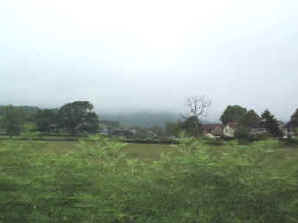
This photograph shows what we believe the crew thought they would see as they approached
the coast. Thick cloud, but relatively clear visibility beneath - we think that
they hoped to break into clear air just above the minimum regulation height for flying
over water ( 500 feet ) having been told that the cloud base was at 600 feet. Perhaps
they believed that there would be fleeting glimpses of the sea and coast from 1000
feet, making it safe to approach the Isle of Wight at a relatively low level. Then
by keeping visual contact round the coast, and while crossing the Solent, they could
make a low level approach into Portsmouth. They had tried a standard instrument approach
a few hours earlier and had been unable to see the airfield, so if their passengers
were going to get home, this was the only way. There was a fair wind blowing and
white horses on the sea would provide a visual reference.
The weather forecast given just before take off was:
- 3/8 - 6/8 cloud between 600 - 1000 feet
- Possibility of complete cloud cover on exposed coasts
- Surface visibility 6 - 10 miles but 1 - 2 miles in rain
- Extensive hill fog
- Visibility 500 - 1000 yards in hill fog
- Wind Westerly 15 - 18 kts gusting to 30 kts.
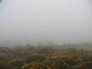
The picture above is of a hillside on a very foggy day with a blanket of cloud about
300' asl. The hillside continues for several hundred feet upwards into the clouds,
but if flying low over the sea, and relying on the forecast weather, there would
be sufficient time to avoid an obstruction. Reducing height in this way while over
the sea did not break any safety rules and was a standard flying procedure although
not perhaps for a loaded passenger plane.

This early picture of Ventnor shows St Boniface Down looming up behind the town.
The crash site is to the extreme right of the photograph. Although the top of the
Down would have been obscured partially or completely, the crew would be expecting
at least 2 or 3 times this distance of visibility from the photographer to the base
of the Down as they approached the coast. With the town between them and high ground,
there would have been little chance of missing the coast.
Unfortunately local visibility was like this.... a few feet. Out at sea it was even
less.....
At the time of the accident, witnesses on the Down said visibility was almost nil
and the cloud appeared to come down virtually to sea level with a base about 300
feet. Conditions were so bad that people within yards of the accident neither heard
nor saw anything until alerted by someone literally on the spot. This is not uncommon
on this coastline and a number of aircraft have hit the hills in dense fog.
It was later confirmed by an eye witness acting as a lookout on a Trinity House ship
off the Needles at the Western end of the Island that the fog was actually on the
sea and so thick that visibility was just a matter of feet and he couldn’t see the
bow of the ship from the lookout position. The cloud and fog bank began almost at
the start of the Island and had a defined edge so that the aircraft would suddenly
have encountered a wall of cloud and far from having reasonable visibility below
600 feet, there was almost zero visibility at sea level.
If, as would seem likely the crew were relying on a weather forecast issued less
than an hour before. The sudden change in visibility from the expected minimum of
a mile, possibly as far as ten miles, was unexpected and the track of the aircraft
as far as can be ascertained would indicate that they were turning away from the
Island and climbing back to a safe height when they hit the Down. To be advised that
the visibility was somewhere between one and ten miles and to find it nil might be
considered to be a contributory factor although the enquiry made no mention of this
and referred to the forecast as 'accurate'.